F35 High-Speed Cycle Route Twente
F35 is the name of the longest high-speed cycle route that is currently in planning and under construction in the Netherlands. The almost 60 kilometres (37 miles) long cycle route can be found in the east of the country in the region Twente, on the border with Germany. The larger cities in the region are Enschede and Hengelo.
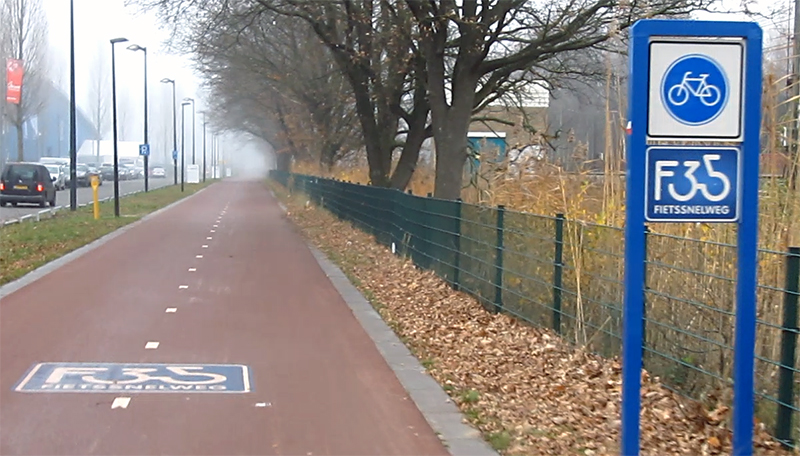
The start of the Enschede – Hengelo segment of the F35 High-Speed Cycle Route. The sign says: “Fietssnelweg”, literally “bicycle-fast-way”, a variation of “car-fast-way” or “Autosnelweg”, which is the normal Dutch term for ‘motorway’.
The modal share of cycling in the region Twente was 32% in 2005, above average for the whole country (27%) but it was decreasing. Reason for concern with the local governments. Investigations revealed some reasons for that decline: increasing journey distances due to urban sprawl, incomplete cycle routes, having to stop too often in the urban areas and the increasing availability of motorised transport. To stop that decrease in cycling the region set up a Regional Mobility Plan (2007) in which they stipulated the ambition to get the modal share of cycling back to the levels of 1995. To achieve that goal, a high quality cycling network needs to be built. A crucial part of the network is the F35 High-Speed Cycle Route, the back bone of the network. For this fast, safe, pleasant and non-stop regional cycle route, a separate Master plan was published in 2009.
A quote from the F35 Master plan (2009)
“The potential of the F35 is considerable. It is not only about cycle journeys along the full length; when multiple connections will be created, it will make the F35 an attractive alternative to the car on shorter journeys. The F35 is multi-functional and has a number of objectives:
- Reducing congestion on motor routes to the city centres, railway stations, offices and event locations by providing a good alternative to the ever-increasing motor traffic (mobility aspect)
- Connecting cities, towns, villages and recreational destinations (recreational aspect)
- A fast connection to the central areas where most people work and live and where most public amenities can be found (economic aspect)
- A fast connection between the city (parts), villages and new urban areas to connect people from all social backgrounds (social aspect)
- A contribution in reducing CO2 emissions and noise levels (environmental aspects)
- Stimulating physical exercise by cycling (public health aspect)
- Reducing the number of traffic casualties (traffic safety aspect)
- A visible project to put the region Twente on the map (PR aspect)”
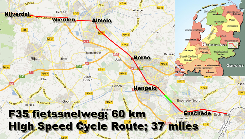
The entire 60 kilometre route of the F35 High-Speed Cycle Route. The green part represents the finished connection between Enschede and Hengelo and it is the part where the videos were shot.
The name F35 was derived from the important regional motorway A35. The public will easily understand the route that way, and know that A = Auto (car) and F = Fiets (bicycle). So the F35 will be the cycle alternative to the A35 motorway and it follows roughly the same route. The cycle route will also be mostly along the railway lines, since they also follow a similar route. Planning the route next to the railway lines has a number of advantages. The railway lines are straight, and generally there is a strip of land available right next to the tracks, that can be used. Since most crossings with larger roads are already multi-level, it is easy to make the crossings for the cycle route grade-separated as well. This increases the safety for cyclists. The railway lines also take cyclists to the most important destinations: the railway stations, which are often located in or near the town centres, which are in turn also important destinations. Unfortunately the proximity of the railway tracks has some disadvantages too. In the video I show you that at grade crossings of roads with the railway lead to the cycle route having to give way to those roads. This is not according to the main design principles of the Master plan (point 3.3 see below) but derives from the conflicting design regulations from the Railways (point 11). Furthermore, a side line of the rail road that has to be crossed near Hengelo, is dangerous, due to the sharp angle of the rail tracks and the cycle route at the crossing.
But apart from these minor negative points the rest of the route between Enschede and Hengelo is perfect. When the entire length of the route is built like that, it will form an excellent fast cycle highway.
A look a the Enschede – Hengelo segment of the F35 High-Speed Cycle Route.
The route is planned to be built in logical segments in the period 2008-2020. Other parts have also been finished, such as a part of the route in Almelo. Because so many details of the route are still unknown, the total costs can only be estimated and have a broad range: from 38.4 to 82.1 million euros for a total of 59.5 kilometres. Of this distance, 16 kilometres will be a totally new route, 15 kilometres are alongside existing roads, and 28.5 kilometres can be found alongside the rail road.
Full real-time ride on the F35 from the edge of Enschede to the edge of Hengelo
Design principles of the F35 High-Speed Cycle Route
Outside the built up area:
- Profile: bi-directional cycle path with a minimal width of 4 meters.
- Where motor traffic intensities are below 5,000 vehicles per day, a cycle street is sufficient.
- Intersections with:
- distributor roads: grade-separated;
- district access roads: grade-separated or roundabout;
- estate access roads: at grade crossing with priority for cyclists.
In the built up area:
- Profile district access streets: bi-directional cycle path with a minimal width of 4 metres (in the largest cities 4.5 metres). Separation from pedestrians; a footpath with a minimal width of 2 metres next to the cycle track.
- Profile estate access streets: bi-directional cycle path with a minimal width of 4 metres (in the largest cities 4.5 metres). Where motor traffic intensities are below 2,500 vehicles per day a cycle street is sufficient.
- Intersections:
- Maximal delay 15 seconds per kilometre.
- District access streets: main arterial streets, grade-separated, other streets, at grade or roundabout with priority for cyclists or traffic lights with a maximal red time of 30 seconds.
- Estate access streets: cyclists have priority.
Other design characteristics:
- The surface must be very smooth, the route has to be lit and planting should provide protection against the wind. Inclines must be below 4%.
- The route must have a high sense of social safety. This can be enhanced by proximity of housing or amenities with a lot of people and by the lights.
- At the locations of offices, railway stations and other public amenities there should be ample parking for bicycles, with (repair) services and rental bikes such as Public Transport bikes (OV-Fiets).
- The design follows the design principles of the CROW design manual for bicycle traffic.
- Where the cycle route runs parallel to the railways it must comply to the design regulations of the railway company.
- The distance to the railway tracks is preferably at least 2 metres (with a minimum of 1.2 metres).
- The cycle route has sufficient connections to the local cycle network. The mesh width should not exceed 300 metres in the built up area and 500 metres outside the built up area.
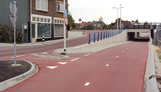
Another finished part of the F35 High-Speed Cycle Route can be found in the city of Almelo.